 I really like the ability to simply ask Siri for directions rather than typing in a destination, so I tend to use Apple's Maps app over Google Maps. But both are excellent. I want to point you to a couple detailed reviews, in case you're wondering which app you should favor, and also want to note the ability of Apple's Maps app to cache large areas of data, so that you can use the app even if you don't have an Internet connection.
The always-excellent TidBITS website posted a detailed article by Adam Engst comparing the two apps last month. It discusses the strengths and limitations of each. Engst says that the ability to use Siri with Apple Maps is strongly in its favor, but that it falls down in terms of accuracy compared to Google Maps — though he says overall there's probably not a significant difference. He notes that while Google Maps offers transit directions, one can also use Apple Maps for transit directions simply by adding "via transit" to one's request. He says the apps are similarly effective in offering voice-guided turn-by-turn directions.
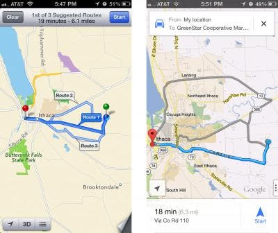
Engst compares the two apps visually, with side-by-side screen shots related to locating a business, satellite and traffic views, information about a location, the interface for setting up a route, the map-based directions the apps provide, and the text-based turn-by-turn directions. In some instances one app does better than the other, so depending on your needs, you'll want to check out which app is the stronger in each case.

Also, David Pogue of the New York Times has a detailed review of Google Maps. He concludes, "But for a 1.0 app, created in the space of only a few months, Google Maps for iPhone is an astonishingly powerful, accurate, beautiful tool." At the end of the article he gives the juicy tidbit that Google says a version for iPad will be coming soon, as well as the ability for offline viewing.
In my mind, one key feature makes Apple's Maps stand out: its ability to cache maps for offline viewing. This is crucial. I was relying on Google Maps last summer when traveling and was surprised at the large areas where it didn't work simply because I didn't have a cellular data connection. I quicky paid $50 for the Tom Tom app, just so I could be sure to always have maps available even if I don't have a connection. In fact, offline maps are likely the main attraction of the commercial maps apps.
A great article on AppleInsider last fall went into detail about the efficiency of vector graphics in Apple's Maps and the app's ability for offline use. The author tested the app in San Francisco and said that once he loaded the map, he was able to browse offline the entire continent at the level of state outlines. At the level of detail with highway information, he was able to navigate most of California while offline, with detailed street-level maps as far away as Salt Lake City (a distance of about 740 miles). This was the case even though he hadn't looked at these areas while connected. It was enough that he accessed the app in San Francisco. Even the satellite view was available offline. By way of comparison, the old Maps app would capture a radius of less than 10 miles.