iView: iPhone in Nature


My wife and I are most fortunate to own and share 33 acres of rural Iowa forest with birds, trees, plants, grasses, insects, fish, reptiles, small mammals, and deer. Admittedly, staring at my iPhone when walking in our woods is not a good look. Yet, worlds have opened thanks to apps that let me name trees, identify birds, diagnose plant health, and plot our newly created paths.
My California-based sister-in-law, a birder, came to visit this spring. Early morning, birds chirping, we walked outside onto our deck. Carolyn pulled out her iPhone, opened an app called Merlin (free), and started to record. In a little over a minute, small photos with names—Northern Cardinal, Eastern Towhee, and Gray Catbird to name a few—appeared on her screen. Deciding to familiarize myself with the Gray Catbird, I tapped on its name, listened to sample chirps, viewed a larger picture, and read a description. For more great app recommendations, be sure to sign up for our free Tip of the Day newsletter.
Later, I installed Merlin on my iPhone, downloading a regional-based portion of the database. The download allowed me to identify birds on the property without cell service. Merlin also can identify birds from photos, but sound identification is easier. In a week, Carolyn recorded 51 different birds on our property.
To identify the variety of species in our woods, I’ve subscribed to Picture This at $30 a year. The developer states that Picture This can identify more than one million species of plants, flowers, herbs, shrubs, and trees with 98 percent accuracy. Although the app is impressive, several times I used it to identify a tree from the bark and then from the leaves and got different results.
The app works by taking or uploading a photo of the plant or tree. With a Wi-Fi or cell connection, in a few seconds, the name and wonderfully detailed descriptions come up. The app will even diagnose the health of the plant, give suggestions for taking care of it, and warn if the plant is toxic. I save results in “my garden” for future reference and guidance.
I wish that Picture This would allow me to download a location-based database. Offline, the program saves the plant’s snapshot for later processing. When I want results right away, I use the free nature app, Seek. Although not nearly as polished, detailed, or accurate as Picture This, Seek lets me identify the plant or insect in a few seconds when offline.
I’ve had a lot of fun creating paths on our 33 acres that traverse a creek and the woods. What I lacked was a way to map them. I discovered onX Offroad and opted for a subscription ($35/year).
The program uses GPS and a large maps database to do its offline processing. The app displays my location on a map viewable in satellite, topographical, or hybrid mode in two or three dimensions. The map automatically displays the boundaries of our land, the adjacent land, and the names of the various owners.
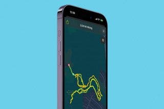
At the beginning of the path, I tap Record Track and start walking. The app draws a line on the map as I walk, giving me live readings of mileage, time, direction, weather, and topography. I can mark the trail with live or stored photos, icons, and area shapes containing acreage numbers. When I’m done, I have created a map of my trail with useful stats and markers.
The app also contains a database of thousands of off-road US campsites, trailheads, and boat launches with trails suitable for hiking, ATVs, dirt bikes, and snowmobiles. onX also offers Hunting and Backcountry apps.
These iPhone nature apps enrich the sights and sounds of our walks through the woods.
Top image credit: 4 PM production / Shutterstock.com

Hal Goldstein
Hal Goldstein is Founder & Columnist at iPhone Life. In 1985, armed with the first HP LaserJet, the original HP Laptop, and his enthusiasm for mobile computing, Hal began a publishing company, Thaddeus Computing. Through the years, the company supported users of HP palmtops, Microsoft Pocket PCs, early smartphones, and the iPhone—Hal is now an avid iPhone and iPad user. Author of the book Meditating Entrepreneurs, he teaches classes and coaches individuals in the Release Technique. Hal lives in Fairfield, Iowa, with his wife, Lynda. You can contact Hal at Hal @iPhoneLife.com.


 Olena Kagui

 Rhett Intriago
 Hal Goldstein
 Kenya Smith

 Devala Rees
 Amy Spitzfaden Both
 Rachel Needell
 Susan Misuraca
 Leanne Hays